Freak 'ball-shaped' clouds appear over Glasgow as UK braces for Storm Dudley
16 February 2022, 20:29
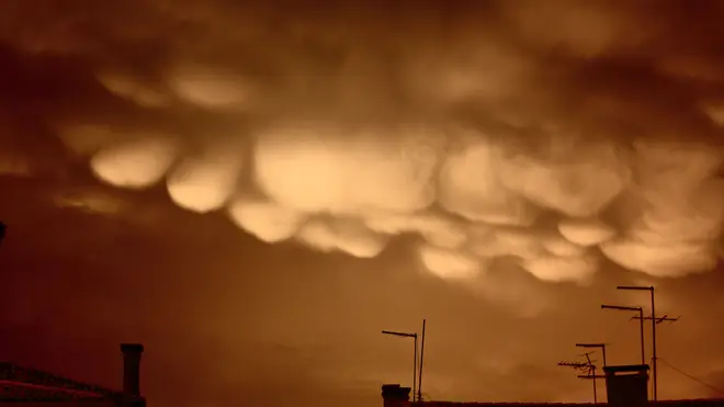

Unusual clouds have formed above Scotland tonight as residents prepare for storm Dudley to batter the UK.
The ominous golf ball shaped clouds were spotted in the skies above Glasgow at the same time as the Met Office weather warning came into place.
Residents were quick to take to social media to share their pictures with one writing: "Who messed with the clouds?"
Weather experts were quick to explain the strange skyscape was due to mammatus clouds.
The Met Office describe mammatus clouds as some of "the most unusual and distinctive clouds formations with a series of bulges or pouches emerging from the base of a cloud".
The shape of mammatus formations can vary widely from the classic protruding shape, to a more elongated tube hanging from the cloud above.
Explaining the reason behind the cloud formation, the Met Office said: "Mammatus often forms in association with Cumulonimbus clouds, which in turn bring thunderstorms due to their huge mass of unstable air.
Read more: Danger to life weather warning issued for England as Storm Dudley hits ahead of Eunice
Read more: The Queen, 95, admits she "can't move" very well during engagement at Windsor Castle
Weird clouds over Glasgow... #StormDudley pic.twitter.com/m7QPJiXcZs
— Brian Morrison (@bripmo) February 16, 2022
"Mammatus clouds generally form in the most unstable cumulonimbus, meaning that there is also a chance of hail, heavy rain and lightning in the vicinity, and if the air is cold enough during winter they can produce snow.
"Sometimes mammatus may form on other cloud types which produce no rain, though this is far less common."
An amber warning for strong winds covering central Scotland, parts of Northern Ireland and northern England above Hull is expected to last until midnight on Wednesday, with yellow wind warnings in place as far south as Birmingham.
Social media users shared images and videos of fallen trees, large waves smashing coastal areas, howling winds and rain sweeping through quiet roads and dark and gloomy skies, with some facing delays on public transport.
Met Office forecaster Greg Dewhurst said: "We've seen Storm Dudley move in over the course of today with strong winds and heavy rain across northern parts of the country.
"This is a complete contrast to areas in the south which have been rather mild and calm for the most part, the temperature even reaching 17C in some areas.
Read more: Andrew 'determined to attend Philip's memorial service' after £12m sex case settlement
Read more: Police officer filmed hitting teenage football fan with baton found dead weeks before trial
OK. WHO MESSED WITH THE CLOUDS?!
— PlanetB 🌎 (@PlanetBGlasgow) February 16, 2022
😨🤯#CloudsGlasgow #Glasgow #Cloud ☁️ pic.twitter.com/PeQCrRvmhA
"Exposed areas in Scotland, Northern Ireland, parts of Wales and northern England have seen wind speeds largely between 60 and 70mph but the worst affected areas have reached and even surpassed 80mph this afternoon.
"In terms of rainfall the highest we've seen in the past 24 hours is 36.8mm in Low Laithes in west Yorkshire, which is a good amount for the time period.
"These conditions are likely to continue into the evening before mellowing out in the early hours of Thursday."
Storm Eunice is then set to strike on Friday which could be even more damaging, with stronger winds than Dudley, heavy snow and possible blizzard conditions.
Another amber warning has been issued, with the potential for stronger winds, and predictions that gusts could top 90mph in the South West and South Wales.
The Environment Agency has also warned of the risk of flooding to coastal areas in southern England on Friday.


