Exact date summer sun will return as 32C heatwave set to hit 'within days'
4 August 2023, 11:37


Brits could soon again be basking in scorching heat as temperatures are set to soar as high as 32C in coming days.
Listen to this article
Loading audio...
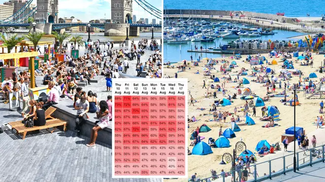
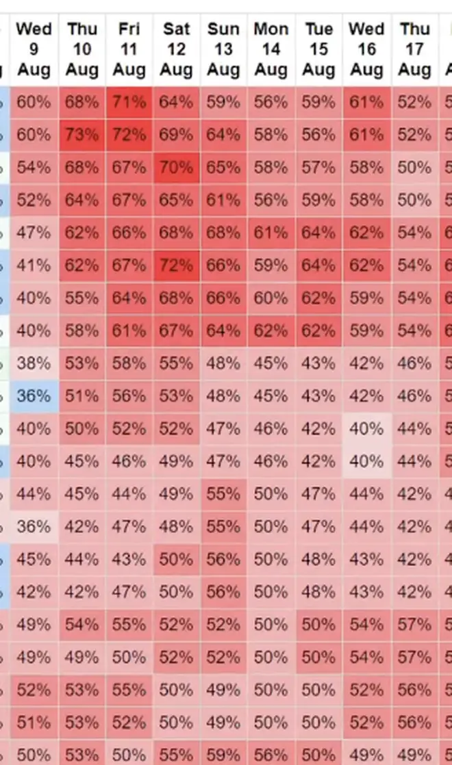
Heat maps for August have turned red as part of what is expected to be a late summer surge in temperatures.
Despite July being mostly a washout, warmer conditions are expected to return by mid-August at the latest.
An Azores high pressure system is set to bring warm air to the UK, with GFS weather forecasting a heatwave as a result.
Read more: UK high streets suffer worst July trading since 2009 due to heavy rainfall
Read more: August weather forecast: What's the outlook and will the UK get a heatwave?
"There should be a south to north progress with 32C in southeast England by August 12, in my opinion, though, it's still a forecast for now," British Weather's Jim Dale said, according to BirminghamLive.
"The gradual change is simply down to a change in airstream; cool northerlies at times this week.
"Warm/hot southerlies later next week as the high pressure tracks across us and then out to the east."
However, the Met Office is less so sure that the warmer weather will be making a return for a prolonged amount of time.
Forecaster Rachel Ayers said although things could "settle down", she is sceptical about anymore heatwaves being on the way.
But there is still a risk of thunderstorms across the country, the Met Office said.
The weather agency's long-range forecast for the first of half of August said: "Sunshine and showers are likely for many at the start of this period, locally heavy and thundery, with northwesterly or northerly winds bringing cool temperatures for the time of year.
"Showers may temporarily ease slightly, however there is some risk that this could give way to further wet and windy weather arriving from the west over the weekend.
"Beyond this, changeable conditions are likely to dominate through the rest of this period. Showery conditions are likely, along with the risk of longer spells of rain and stronger winds at times too.
"Some drier and brighter interludes are also possible, these perhaps more likely later in this period. Often breezy, especially earlier in the period. Temperatures are likely to be mostly below average."