Back to work weather warnings: Maps show 300mile wall of rain and 65mph gales as Storm Henk hits Britain
2 January 2024, 08:54 | Updated: 2 January 2024, 09:16


The UK is set to be hit by heavy rain and very windy weather, as the Met Office announces yellow and amber weather warnings.
Listen to this article
Loading audio...
Storm Henk is expected to bring strong winds which could damage buildings and force the closure of some bridges and roads.
The Met Office warned of the dangerous effects of Storm Henk on Tuesday, days after Storm Gerrit battered the UK.
Debris thrown into the air could cause injuries, so the Met Office is recommending that people exercise caution when travelling.
It also warned that large waves and debris thrown onto coastal roads, sea fronts, and properties present a danger to life.

It warned: "Following recent wet weather, further spells of rain, heavy in places are expected on Monday evening and overnight. Then after a brief gap, another spell of heavy rain is likely to spread northeastwards on Tuesday.
"On Tuesday the focus for the heaviest rain is less clear-cut but perhaps more likely across parts of Wales, the Midlands towards eastern England and Yorkshire. Over the warning period, 15 to 30 mm rain is likely to fall fairly widely, with a few places seeing 35 to 50 mm.
"The worst of the rain should clear southwestern areas of England and south Wales by around the middle of Tuesday but could last into the evening across the northeast of the warning area. Strong winds will affect parts of the area, with a separate wind warning in place."
The Met Office said it's possible that heavy rain will mean homes and businesses will be flooded in certain areas.
Flooding could affect roads and make journeys longer, so it suggests that drivers take extra caution.
Met Office meteorologist Jonathan Vautrey said: "At the moment it does look like a lot of that rain will push across the vast majority of England and Wales, turning widely wet once again throughout Tuesday."
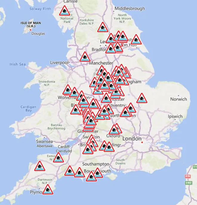
There are 114 flood warnings and 261 flood alerts across England.
Coastal areas will be affected by large waves and sea spray.
The Met Office said: ""In coastal areas winds are likely to gust towards 60mph at times, with a lower likelihood of 70mph gusts.
"Inland gusts of 40 to 50mph are likely but with a smaller chance of 55 to 60mph gusts, although the extent of such gusts carries low confidence at present."
There are 36 flood alerts across Wales, where flooding is a possibility. Rivers Ely, Hydfron, and Ritec have flood warnings in areas where flooding is expected.

The Met Office said heavy rain will affect:
- East Midlands
- East of England
- London and South East England
- North West England
- South West England
- Wales
- West Midlands
- Yorkshire and Humber
It is recommended that people who are planning to travel in areas affected by the yellow warnings check road conditions before making their journey and to allow for extra travel time.