Exact areas set to be covered in four days of snow and ice as Arctic cold plunge brings temperatures of -10C
16 January 2024, 00:08
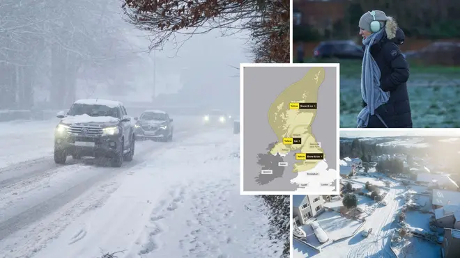


These are the exact regions issued with snow and ice warnings across the UK.
Listen to this article
Loading audio...
Met Office forecaster Greg Dewhurst said temperatures could drop as low as -15C on Tuesday.
He said the north west of England could see heavy snow, although it is not likely to be anymore extreme than snow seen in previous years.
“In the north it will be pretty heavy, not really unusual I don’t think, it will be across the north and the north west while there will be little in the south,” he told the Mirror.
“Widely across higher ground 10 to 20 centimetres of snow and up to 30 to 50 centimetres on Thursday. Northern Ireland 10 centimetres on higher ground and similar in northern England were it can build up to 20 centimetres. On lower ground it might a few centimetres.
“The snow will build up over the coming days but I wouldn’t say it is anything unusual for the time of the year, we’ve had very cold spells over recent years and so nothing overly exceptional. It will be very cold and there will be heavy snow in the north of the UK and some flurries in the south.
"But snow builds up as has already been seen with about 15 centimetres around Aberdeen. The temperature -10C to -13C tonight in Scotland and -15C tomorrow on higher ground as well as lower rural areas."

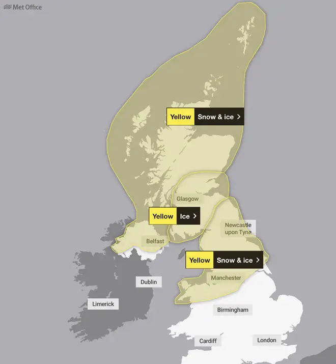
The yellow snow and ice warnings were originally issued for Northumberland, the Lake District, the Pennines, and wider areas of the North West and Wales starting on Monday until Thursday.
But weather alerts have now been extended to include parts of north east England and potentially some parts of southern England on Wednesday.
It comes as an Arctic blast saw three inches of snow arrive in parts of Britain on Monday.
Temperatures hit as low as -10C on Monday in the Highlands, followed by -5C in Glasgow, Staffordshire and Cumbria.
Comparatively, Exeter was the warmest region in the country at 6C.
The updated Met Office forecast reads: “Further snow showers, perhaps merging into a longer spell of snow, are likely to cause further disruption on Tuesday.”
The forecaster has warned of potential travel delays on roads amid the snow showers, as well as potential power cuts, delays or cancellations to rail and air travel.
Some 200 schools across Aberdeenshire, Moray and Shetland were closed on Monday due to the three inches of snowfall overnight.
Flooding risks remain in place for parts of England, particularly the south, as the Environment Agency issued 27 warnings and 118 alerts on Monday.
Meanwhile trains between Oxford and London were disrupted on Monday after rail lines between Haddenham and Thame Parkway and Bicester North were shut due to a landslip.
Met Office chief meteorologist Andy Page said: “Where and how much snow we will get will vary throughout the week and weather warnings could change quickly, you will need to keep an eye on the forecast for your region for the latest information.
“There will be widespread frost this week and we could see some fairly deep laying snow in parts of northern UK and strong winds could result in drifting or blizzard conditions at times.
“The snow and ice will be disruptive and could potentially impact travel plans, make driving dangerous and pavements slippery.”
Full list of areas set to see snow:
-Angus
-Clackmannanshire
-Dundee
-Falkirk
-Fife
-Perth and Kinross
-Stirling
-Derbyshire
-Aberdeen
-Aberdeenshire
-Moray
-Highlands & Eilean Siar
-Eilean Siar
-Highland
-Durham
-Northumberland
-Blackburn with Darwen
-Blackpool
-Cheshire East
-Cheshire West and Chester
-Cumbria
-Greater Manchester
-Halton -Lancashire
-Merseyside
-Warrington
-Orkney Islands
-Shetland Islands
-Dumfries and Galloway
-East Lothian
-Edinburgh
-Midlothian Council
-Scottish Borders
-West Lothian
-Argyll and Bute
-East Ayrshire
-East Dunbartonshire
-East Renfrewshire
-Glasgow
-Inverclyde
-North Ayrshire
-North Lanarkshire
-Renfrewshire
-South Ayrshire
-South Lanarkshire
-West Dunbartonshire
-Ceredigion
-Conwy
-Denbighshire
-Flintshire
-Gwynedd
-Powys
-Wrexham
-Staffordshire
-County Antrim
-County Armagh
-County Down
-County Fermanagh
-County Londonderry
-County Tyrone
-North Yorkshire
-South Yorkshire
-West Yorkshire
Met Office deputy chief meteorologist Nick Silkstone said: “The track of this system still has some small but all-important uncertainties tied to its northern extent, and it has the potential to bring some snow to southern England.
“However, our preferred solution suggests minimal snowfall - a couple of centimetres at most - across parts of the extreme south of England in association with this system, but we are keeping an eye on how things develop and will update the forecast as needed.”
Met Office meteorologist Liam Eslick said that temperatures will be about 5C to 6C lower than usual for this time of year.
Mr Eslick said: "Especially towards the North where we do have these warnings, we're likely to see some travel disruption.
"So we would recommend people stick to the main roads and avoid country lanes where possible.
"These are the places that aren't going to see any gritting or any road clearances for the next couple of days.
"So we recommend people take their time, make sure they have time to do their cars in the mornings, and go steady."
He said: "So essentially we're looking at a strong northerly wind which is bringing in Arctic airmass which is cold, which is bringing in these wintry showers."
He said that "icy conditions" were expected, with maximum temperatures of 0C in parts of Scotland, and only 2C to 4C in southern parts of the UK.