Met Office issues yellow weather warnings for ice with Brits cautioned over icy surfaces and injury risk
1 January 2023, 18:11 | Updated: 1 January 2023, 22:57


The Met Office has issued yellow weather warnings for ice, as the forecaster cautions Brits over icy surfaces and the risk of injury.
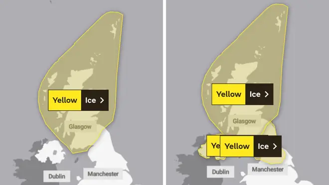
The warnings cover the North of England and across Northern Ireland from midnight tonight until 11am tomorrow, and the whole of Scotland from 6pm today until 11am on Bank Holiday Monday.
The forecaster warned there could be injuries from slips and falls on icy surfaces, and there would probably be some icy patches on some untreated roads, pavements and cycle paths.
It added: “Following recent wet conditions, surfaces are likely to remain wet into Monday morning and, with a cold night, icy stretches will readily form on untreated surfaces, adding: “A few rain, sleet and snow showers may still affect these areas overnight but ice remains the main hazard.”
A snow warning across central, northern Scotland had been in place until noon today.
Read more: Thousands of revellers line the streets of London for New Year's Day Parade
This morning, Met Office meteorologist Dan Stroud said: “We have got an area of rain and hill snow across Scotland and that is moving northwards as we speak.
⚠️ Yellow weather warning issued ⚠️
— Met Office (@metoffice) January 1, 2023
Ice across northern England, Northern Ireland and southern Scotland
Monday 0000 – 1100
Latest info 👉 https://t.co/QwDLMfRBfs
Stay #WeatherAware⚠️ pic.twitter.com/xGhjQmBNCj
“But that rain and hill snow will eventually move out into the Northern Isles, late Sunday afternoon/evening, leaving behind a few showers across the bulk of Scotland but with lighter winds and clear spells developing.
“We’re expecting temperatures to drop quite quickly, quite widely – actually below zero – with some rural spots getting down to minus 7C, minus 8C tonight in the Highlands.”
Altnaharra in the Highlands recorded a low of minus 8.6C yesterday night, and similar overnight temperatures are expected to be seen in rural spots today.
⚠️ Yellow weather warning issued ⚠️
— Met Office (@metoffice) January 1, 2023
Ice across Scotland Sunday 1800 – Monday 1100
Latest info 👉 https://t.co/QwDLMfRBfs
Stay #WeatherAware⚠️ pic.twitter.com/tfbdLpP1hY
Mr Stroud added: “The rest of the UK, certainly a colder night than the night just gone… a few showers moving off of the north and west around Liverpool Bay area across the Lake District, and those will leave behind wet surfaces during the course of the afternoon and into the evening.
“So we’re expecting temperatures to get low enough for a few icy stretches to develop by around midnight across parts of Northern Ireland and northern England.
“The big thing tonight, most people will notice across England and Wales, is it will feel colder than it has done the last few nights. We’re looking at temperatures into mid-single figures with a rural frost possible in parts of Wales, for example.
🌦️ It will be mild in the south, with a chance of showers this afternoon
— Met Office (@metoffice) January 1, 2023
🌡️ Feeling colder further north, but cloudier, with showers gradually easing later pic.twitter.com/IjxEMTK8g7
“There’s the risk of some icy stretches around, so definitely anyone out early tomorrow morning just needs to take some care.
“We’re expecting a lot of wet weather as we move into the working week.
“The best day of the week is probably going to be Bank Holiday Monday, with a lot of dry and generally fine weather across the country, a bit of a cloud in the mix, with cloud and rain moving in early Tuesday morning.
“And then our focus gets to a spell of wet weather (on) Tuesday into Wednesday and that could produce quite a bit of rain across some western locations.”