
Brits to be buried in '600-mile wall of snow' as Scandinavian freeze sweeps the UK with up to 10cm set to fall
30 November 2023, 14:32


Brits are set to face a 600-mile wall of snow as a Scandinavian freeze sweeps the UK.
Listen to this article
Loading audio...
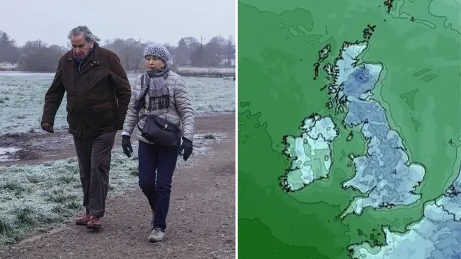
Weather maps from WX Charts have shown up to 200cm of snow could fall in some areas in coming days - with at least 10cm of snow falling just today.
It comes as the cold snap is set to continue into the second week of December.
London, Birmingham and Sheffield are expected to be blanketed, with most of the UK facing a 600-mile wall of snow. And the mercury could even dip as low as -10C in some places.
The Scottish Highlands will see the worst of the freezing conditions, with snow set to be as deep as 200cm.
Read more: Snow blankets Britain: Met Office issues snow and ice warnings as temperatures set to plunge to -8C
Read more: Snow set to hit London as forecasters issue three day weather warnings for 795 miles of the UK
❄️ Wintry showers in the southwest and along North Sea coasts
— Met Office (@metoffice) November 30, 2023
🌤️ Plenty of sunshine elsewhere but feeling cold
⚠️ Stay #WeatherAware pic.twitter.com/6OxxEcupda
The Met Office said: "There will be widespread overnight frosts for much of the UK in the coming days and a risk of snow for some regions.
"Much colder conditions are expected to affect the UK for the rest of this week and into the weekend, with daytime temperatures rooted in single figures and overnight temperatures falling well below freezing in many places.
"With the UK sitting in cold air from Scandinavia the weather is turning much colder for the rest of this week and the start of next with daytime temperatures struggling to get above single figures and overnight temperatures staying below freezing for much of the country."
⚠️ Yellow weather warning updated ⚠️
— Met Office (@metoffice) November 29, 2023
Snow across parts of Scotland and northeast England
Valid until Thursday 11:00
Latest info 👉 https://t.co/QwDLMfRBfs
Stay #WeatherAware⚠️ pic.twitter.com/NygKyFuxSZ
Yellow weather warnings for snow and ice have been issued across most eastern parts of the UK.
There are also warnings in place across south west England and Ireland.
Met Office Chief Meteorologist, Neil Armstrong, said: "We’ve already seen snow settling in parts of eastern Scotland and northeastern England.
"As the cold air continues to spread across the UK we also expect to see some snow over the high ground of southwest England overnight tonight and through tomorrow.
"Snow showers will continue along the North Sea coast with a northeasterly air flow, leading to further accumulations over higher ground.
"Where the showers fall as rain there is a risk of icy patches forming overnight with temperatures widely dipping below freezing."
⚠️ Yellow weather warning issued ⚠️
— Met Office (@metoffice) November 30, 2023
Ice across parts of southwest England
Thursday 2200 – Friday 1000
Latest info 👉 https://t.co/QwDLMfRBfs
Stay #WeatherAware⚠️ pic.twitter.com/AAGLCrem3S
Parts of Dartmoor are expected to see 5-10cm of snow on Thursday, with other parts of the south west seeing 1-3cm.
Overnight, temperatures are forecast to drop as low as -8C.


