
Exact date storm set to hit UK amid sub-zero temperatures as 'danger to life' warning issued over 70mph winds
18 January 2024, 06:15 | Updated: 18 January 2024, 11:33


Brits will continue to face freezing conditions heading into the weekend before stormy weather hits large swathes of the UK.
Listen to this article
Loading audio...
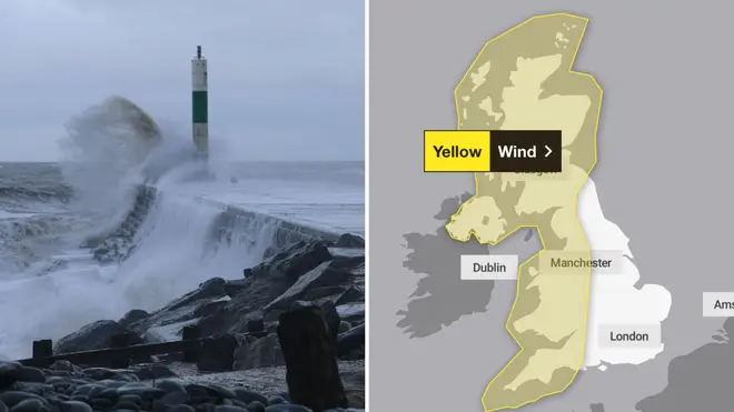
The Met Office issued a warning for wind across most parts of the UK, with disruption to travel and utilities expected.
There is a slight chance of damage to buildings, such as tiles blown from roofs, as well as power cuts.
There is also a risk of Injuries and danger to life from large waves and flying debris in coastal areas, the Met Office said.
It comes as there are already amber and yellow warnings for snow and ice in place across Scotland on Thursday and heading into Friday.
Temperatures were expected to plummet as low as -18C in Scotland overnight, becoming the coldest January night since 2010.
Some rural spots of England and Wales could also drop close to between minus 5C to minus 10C with very cold widespread frost.
Read More: Exact date warmer weather to return as 15C and sunshine predicted after cold snap
A big change is on the way.....
— Met Office (@metoffice) January 17, 2024
Find out more in the full 10 day trend 👉 https://t.co/DRKJmHC7V9 pic.twitter.com/iFVsaZZN7c
Wind coming in from the Atlantic in the west will then take charge through Friday and into Saturday, bringing much milder, wet and windy weather for the weekend.
The Met Office outlook for the weekend says: "Turning mild, wet and windy through the weekend and into next week. Gales or severe gales likely on Sunday, especially in the northwest. Locally heavy outbreaks of rain at times."
Met Office meteorologist Alex Burkill said: "It is on Sunday where we're likely to see the wettest and windiest weather, particularly towards northern and western parts and that's where we're likely to see the greatest risk of disruption."
It adds: "As well as the wet and windy weather, the position of this low is going to drag in some milder air from the southwest so temperatures are going to go from several degrees below average to several degrees above average."
Any snow on the cards where you are on Thursday? ❄️
— Met Office (@metoffice) January 17, 2024
You can find out in the 4cast below 👇 pic.twitter.com/eYypSrJKnT
The UK had its coldest night of the winter so far on Tuesday, which forced hundreds of schools in Scotland to stay closed.
An amber warning for snow across northern Scotland, the Orkney and Shetland Islands is still in place until 6pm on Thursday, with the potential of up to 20cm more snowfall.
Parts of Shetland already saw around 23 to 24cm of snow on Wednesday, while snowfall even reached the far south-east of England, the Met Office said.
Other parts of Scotland and Northern Ireland have a yellow snow and ice warning spanning the whole of Thursday.
A final yellow ice warning for south-east England, in particular south-east London, will run until 10am on Thursday.
Conditions will be clearer with more sunshine inland on Thursday and very cold by night under clear skies, meteorologist Marco Petagna said.
While another frosty night is forecast into Friday it will be breezier with more cloud in places, but lows of minus 10C will again be likely in some areas.


