
Exact date hot UK weather will return as Met Office issues warning for strong winds and torrential rain
4 July 2023, 14:15


The Met Office has given its verdict on when the hot weather will return amid warnings of heavy rain and strong winds.
Listen to this article
Loading audio...
The month kicked off with blustery and rainy conditions across the UK but Brits will soon be able to return to basking in the sun as temperatures soar.
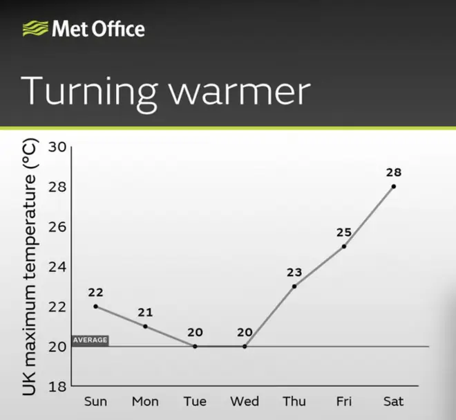
Conditions are expected to gradually change this week, reaching highs of 28C as soon as Friday.
Want to know how the weather will be looking this week?
— Met Office (@metoffice) July 3, 2023
Here's Annie with your forecast for the week ahead 👇 pic.twitter.com/RPL96fZBdb
The Met Office's Annie Shuttleworth said eastern areas would experience drier conditions while showers remain in the west.
"We'll continue to see some rain but it just tends to skirt along the west coast with higher pressure still dominating in the east bringing dry weather that will allow for more sunshine and higher temperatures," she said.
"So a decent day on Friday, it’ll start to feel quite hot and humid in the east.
"But in the west we continue to see some relatively brisk winds with persistent rain throughout a lot of the day."
Read more: Met Office issues stark warning over climate change after recording hottest June ever
Read more: When is the 40 degree heatwave? Met Office forecast soaring temperatures
⚠️ Yellow weather warning issued ⚠️
— Met Office (@metoffice) July 4, 2023
Rain and wind across parts of eastern England
Today 2100 – Wednesday 0600
Latest info 👉 https://t.co/QwDLMfRBfs
Stay #WeatherAware⚠️ pic.twitter.com/DSJ6t9j8CK
Wet conditions are still expected for a few more days due to an area of low pressure closing in on the UK.
The Met Office issued a yellow weather warning for heavy rain and strong winds across parts of eastern England on Tuesday. It will remain in place from 9pm until 6am on Wednesday.
"Some of these showers could be heavy at times," meteorologist Greg Dewhurst said.
"Odd rumble of thunder is possible, particularly across northern parts of Wales into northern England."
He went on to say: "By the end of the week into the weekend, [temperatures will be] rising towards 28C."
It comes after last month was confirmed as the hottest June on record, reaching highs of 32.2C in Chertsey, Surrey.
Met Office climate extremes principal fellow Paul Davies issued a stark warning about the warmer conditions, saying "human induced climate change has driven up the possibility of reaching record high temperatures".
"By the 2050s the chance of surpassing the previous record of 14.9°C could be as high as around 50%, or every other year," he said.
"Beyond the 2050s the likelihood is strongly governed by our emissions of greenhouse gasses, with the chance increasing further in a high emissions scenario but levelling off under mitigation."
Yet another heatwave has already been forecast for the end of July, with it set to last two weeks. Temperatures are expected to soar to 40C.


