
Exact date torrential rain to sweep the UK as weather maps show return of stormy conditions
15 March 2024, 14:25


Fresh weather maps have shown the exact date torrential rain will batter Britain.
Listen to this article
Loading audio...
Heavy rain will sweep the UK on March 26, with temperatures set to plummet as low as 0C.
The torrential downpours are expected to begin from midnight and continue for 10 hours, WXCharts maps have shown.
But they will begin to subside in the afternoon, with lighter showers only hitting the south.
The Met Office long-range forecast says: "A continuation of the changeable but generally mild conditions looks likely but with a tendency for any rain to be heaviest in western, especially northwestern areas while parts of the south and southeast are likely to see longer, drier interludes."
It adds: "There is a small chance of more notable colder conditions developing, most probable across the north of the UK, but at this stage any confidence this possibility looks to be a low risk."
Read more: How to avoid the travel chaos caused by the M25 closure - alternative routes explained
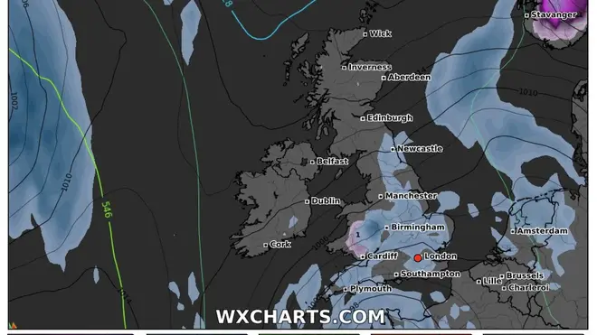
The WXCharts map suggest the stormy weather will spread from Wick in Scotland to Plymouth in Devon.
Scotland is expected to be worst hit, with 38-42mm of rainfall forecast, while northern England could see 15-20mm of rain.
It comes as there is also expected to be a weekend washout, with the Met Office warning of "showers or longer spells of rain" over the next few days.
As of Friday afternoon, the Environment Agency issued 21 flood warnings across England and 101 flood alerts.
Making plans for the weekend? Find out with Alex what the weather has in store 👇 pic.twitter.com/QZSqaxzUzI
— Met Office (@metoffice) March 14, 2024
Jo Farrow, a weather expert from Netweather, said: "The occlusion from the second low will pull southwards on Friday, away from Ireland and slowly down Britain.
"This allows colder air to flow down from the north ready for a clear Friday night. Next, a large Atlantic low pressure begins to edge towards the UK at the weekend.
"This will bring more widespread rain, heading northeastwards through Saturday along with milder air. It clears to a cooler Sunday with bright spells but plenty of showers from the west."
Some areas could even see snow this weekend amid frosty conditions.
Around 2cm of snowfall an hour has been forecast in some areas in Scotland, including Inverness and Fort William.
It is expected throughout Saturday, lasting until about 9pm.


