
Weather warning updated as 'rapidly intensifying' Storm Agnes set to batter Britain
26 September 2023, 15:56 | Updated: 26 September 2023, 16:15


The Met Office have warned that Storm Agnes will ‘rapidly intensify’ as it makes it’s way over the Atlantic Ocean to Britain.
Listen to this article
Loading audio...
The Met Office has issued yellow warnings of strong gales and a deluge of rain likely to cause mayhem on the roads, as well as hit rail, air and ferry services.
In an update the Met Office warned that “Storm Agnes will rapidly intensify during he next 18 hours as it moves towards the UK”.
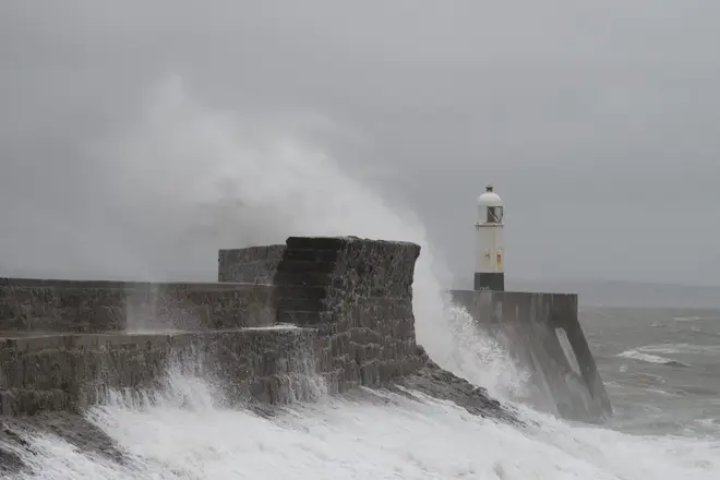
Britons have been warned of travel chaos tomorrow when the storm is due to land in Britain bringing torrential rain and 80mph wind.
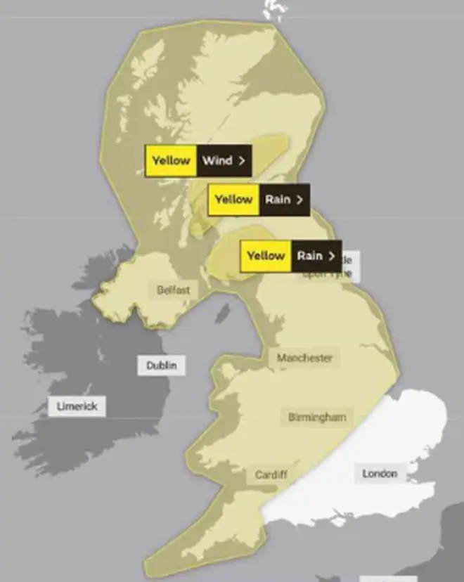
Three yellow warnings have been issued for Wednesday so far, including two for rain and one for wind, with one remaining in place until Thursday morning.
The warning for wind will cover almost the entirety of the UK, sweeping across Northern Ireland, up to northern Scotland and down to the southwest of England. Skipping London and the east of England, it will remain in place from 12.00 on Wednesday until 07.00 on Thursday.
Elsewhere, a separate warning for rain will be in place north of Glasgow from 15.00 tomorrow until 23.59, with the start and end time brought forward from previous predictions. Another warning, in place for the same period, is in place south of Edinburgh, spanning Wigtown and Dumfries.
A danger to life warning was also issued by the forecaster for Wednesday and Thursday.
The country's first storm of the season - which was officially named yesterday - could bring 80mph winds, 2.4in (60mm) of rain and potential floods amid warnings of a "danger to life".
The yellow weather warning is in place from 10am on Wednesday until 7am on Thursday for the whole country apart from southern England and northern Scotland.
There is also a yellow rain warning in place from 9pm on Wednesday to 6am on Thursday in southern Scotland.
Forecasters have warned of "significantly disruptive" wind gusts of 50 to 60mph inland and 65 to 80mph on coasts. Authorities said some roads and bridges could close. Power cuts are also possible while railways, roads and airports could face disruption.
It comes just days after Hurricane Nigel brought torrential rain across the country, causing travel mayhem and flooding in some areas.
Met Office chief meteorologist Steve Ramsdale said: "While the precise track and depth of Storm Agnes is still being determined, there's a high likelihood of wind gusts around 50 to 60mph for some inland areas.
"Exposed coastal areas could see gusts of 65 to 75 mph with a small chance of a few places seeing around 80mph.
"As well as some very strong winds for many, Storm Agnes will also bring some heavy rain, with the highest totals more likely in Scotland, northern England, Wales and Northern Ireland. Around 60mm of rain is possible in a few places over high ground in Scotland."
The Met Office warning stated that there is a "small chance of injuries and danger to life from flying debris".
There is also a "slight chance of some damage to buildings, such as tiles blown from roofs".
It added: "There is a slight chance that power cuts may occur, with the potential to affect other services, such as mobile phone coverage.
"Longer journey times are likely, or cancellations as road, rail, air and ferry services are affected. Some roads and bridges are likely to close.
"There is a small chance that injuries and danger to life could occur from large waves and beach material being thrown onto sea fronts, coastal roads and properties; with a chance of some minor flooding of coastal roads."


