
Exact date Storm Agnes to batter UK with 80mph winds, as Brits warned of 'danger to life'
25 September 2023, 05:50


The UK is set to be hit with winds as strong as 80mph this week, with Agnes the latest major storm to blow onshore.
Listen to this article
Loading audio...
The Met Office has warned that the storm could pose a "danger to life" for some in the UK when it arrives on Wednesday, bringing "some very heavy rain and also some very strong winds."
Forecasters said northern parts of the UK would be the worst affected, with the storm to come across from the Atlantic and over Ireland.
The storm will bring strong winds to 13 parts of the UK in total, including south-west England, north-west and north-east England and parts of Scotland.
Storm Agnes comes after the remnants of Hurricane Nigel and Hurricane Lee caused chaos across much of the UK last week, with widespread heavy rain and some serious flooding.
Read more: Exact date October heatwave to hit as Brits set to 'sizzle' in Indian summer
Read more: Fresh weather warning as bands of rain set to sweep UK causing flooding and travel chaos

Met Office forecaster Craig Snell said: "We are keeping a very close eye on things. We've got a very jet across the Atlantic and that's the breeding ground for some potentially deep areas of low pressure.
"It's one we are keeping a very close eye on is this area as it moves towards the UK onto Wednesday, potentially quite a deep feature as it moves towards our neck of the woods.
"We could potentially see some very heavy rain and also some very strong winds. Some uncertainty on this at this stage, so we are keeping a very close eye on it.
"The main advice at the moment is to keep a very close eye on the forecast."
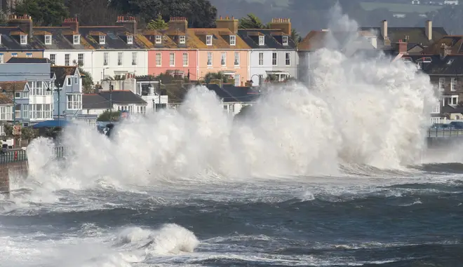
The Met Office said" "There is a small chance that injuries and danger to life could occur from large waves and beach material being thrown onto sea fronts.
Forecasters added: "A deep area of low pressure is expected to approach southwest Ireland early on Wednesday, and track across northern parts of the UK before clearing early Thursday.
"There is some uncertainty on the precise track and depth of the low, however the most likely outcome at present is for a wide swathe of 50 to 60 mph gusts to affect inland areas, perhaps locally stronger over and to the lee of hills in the north.

"Some Irish Sea coasts could see gusts of 65 to 75 mph, with a small chance of 80 mph gusts on the most exposed coasts and headlands."
The Weather Outlook forecaster Brian Gaze said: "There is a real possibility Storm Agnes could arrive. Strong winds and heavy rain could lead to disruption.
"The best advice is to stay up to date with forecasts."
But after the storms clear up, Brits will be treated to an Indian summer, with a mini-heatwave expected in October.
As we move from September into October, there will be unusually high temperatures.I
t could reach as high as 23C in the south, which would be warmer than usual for October, and could mean a mini-heatwave is in store.


